HO CHI MINH TRAIL
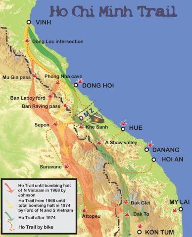
Ho Chi Minh Trail. From 1959 until 1975, North Vietnam employed the Ho Chi Minh Trail (Truong Son Road), a 16,000-kilometer logistical network of forest trails, highways, and tunnels to deliver soldiers and supplies to the South.
During the resistance fight against the United States, a strategic route was crucial in the Great 1975 Spring Victory, which freed the South and reunified the country. That fabled road was the Truong Son Trail, commonly known as the Ho Chi Minh Trail, which symbolized Vietnam's persistent tenacity, tremendous courage, and astonishing innovation.
In 1959, under the leadership of the Politburo and President Ho Chi Minh, the General Military Commission (now the Central Military Commission of the Communist Party of Vietnam) established a "special military task force" (later known as Group 559) tasked with building a strategic supply route through the rugged Truong Son Mountain Range to support the Southern battlefield. This path was eventually renamed the Truong Son Trail - Ho Chi Minh Trail.
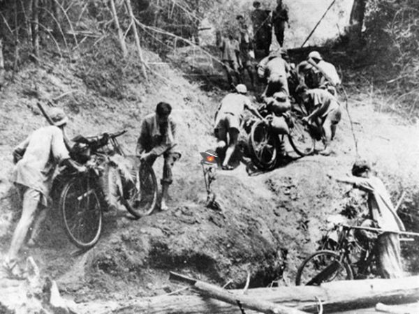
The building and development of this vital route progressed in phases, inextricably linked to the revolutionary success in Southern Vietnam throughout the resistance fight against the US. Vietnamese soldiers and civilians faced unrelenting airstrikes, terrible weather, and treacherous terrain to clear trails, build routes, and move personnel and supplies to the front lines.
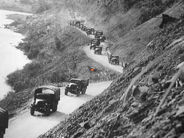
The Truong Son supply route began as a network of tiny paths used for manual carrying and hauling and grew over 16 years (1959-1975) into a vast transit system spanning thousands of kilometers. It included five vertical trunk highways, 21 horizontal routes, about 17,000 kilometers of motorized vehicle roads, more than 3,000 kilometers of communication paths, around 1,400 kilometers of fuel pipelines, and several river crossings and communication lines throughout the route.
This strategic network became a lifeline, connecting Northern Vietnam - the rear base - to the Southern battlefield while supporting several fighting fronts via a variety of transportation means.
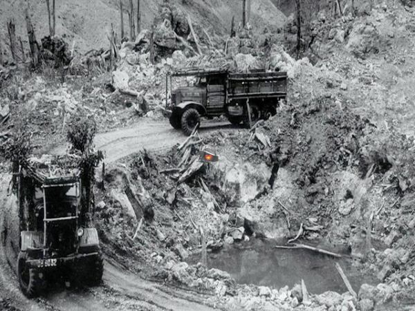
The renowned Ho Chi Minh Trail was also a bloody battleground, with Vietnamese soldiers facing an unrelenting enemy onslaught. The US imperialists and the puppet Saigon administration quickly recognized the trail's critical strategic importance in supporting resistance activities in the South, which might decide the success or failure of their invasion. As a result, they worked tirelessly to obstruct and destroy the trail.
Southern Part:
1: Saigon → Dong Xoai → Gia Nghia → Buon Ma Thuot | 340km
2: Buon Ma Thuot → Pleiku → Kon Tum | 230km
Central Part:
3: Kon Tum → Kham Duc → Prao | 280km
4: Prao → A Luoi → Khe Sanh | 210km
5: Khe Sanh → Long Son → Phong Nha | 230km
6: Phong Nha → Huong Khe → Pho Chau | 180km
Northern Part:
7: Pho Chau → Tan Ky → Cam Thuy | 260km
8: Cam Thuy → Cuc Phuong → Hanoi | 150km
They responded by launching massive efforts to destroy it, making the path into a trial ground for modern military techniques and cutting-edge weaponry. They used "interdiction tactics" and "strangulation warfare" to try to cut off this key supply conduit.
Despite these efforts, under the wise leadership of the Party, the Central Military Commission, and the Ministry of National Defence, Vietnamese soldiers and civilians demonstrated remarkable bravery, resilience, and ingenuity to overcome every difficulty, hardship, and sacrifice, defeating all enemy ruses and ensuring a continuous flow of supplies and personnel to the Southern frontlines.
In its 16 years of operation, Truong Son Trail transported over one million tonnes of weapons, equipment, and other supplies while facilitating the movement of over two million soldiers to the frontlines and evacuating tens of thousands of wounded troops to the North for treatment. During the important 1975 Spring General Offensive and Uprising, the route alone transported 413,450 tons of vital supplies, making a significant contribution to Vietnam's eventual triumph.
A New Chapter in National Development Ho Chi Minh Trail:
If the Truong Son Trail represented the burning yearning for national independence and reunification during the war, the Ho Chi Minh Trail now serves a new purpose: to drive national growth.
Recognizing the strategic importance of the Ho Chi Minh Trail as a critical security and economic development corridor, the National Assembly passed Resolution No. 38/2004/QH11 on December 3, 2004, approving the investment policy for the Ho Chi Minh Highway construction project.
On February 15, 2007, the Prime Minister signed Decision No. 242/QD-TTg, which approved the master plan for the Ho Chi Minh Highway. This huge project encompasses 30 provinces and cities, starting in Pac Bo (the northern border province of Cao Bang) and ending in Dat Mui (the southernmost province of Ca Mau). The overall intended route length is 3,167 kilometers, which includes a 2,667-kilometer main road and a 500-kilometer western extension.
On April 5, 2000, at the Xuan Son Ferry Terminal in the Bo Trach district, the central province of Quang Binh, the Prime Minister officially launched work on the Ho Chi Minh Highway. Today, more than 90% of the project has been completed, and despite not being fully operational, the road has demonstrated its critical role in improving regional connectivity, relieving pressure on National Highway 1A, fostering socioeconomic development, and ensuring border security and defense.
The highway has also contributed to strengthening commercial relations with Laos and Thailand, cementing its place as a key component of North-Central Vietnam's East-West Economic Corridor. Trade with Laos has been made easier in Ha Tinh province because of the Cau Treo International Border Gate. In Quang Binh, it has permitted industrial zone growth and increased tourism to Phong Nha-Ke Bang National Park and historical monuments. In the Central Highlands, the route connects coffee and pepper-growing zones to local and international markets. Localities have boosted agricultural growth, recruited investment, and raised living conditions by capitalizing on this road's potential, greatly contributing to Vietnam's long-term development.
During the resistance fight against the United States, the Truong Son Trail represented the desire for independence, freedom, and national reunification. During peacetime, the Truong Son-Ho Chi Minh Trail serves the purpose of nation-building and development.
Travel on the Ho Chi Minh Trail, also known as the Truong Son Road:
The Ho Chi Minh Trail provides a stunning, historical motorcycle or car trek over Vietnam's Truong Son Mountains, best done between March and September. The road, which frequently leads from Hanoi to Kon Tum, combines battle history at monuments such as Khe Sanh with picturesque rural landscapes and ethnic settlements.
Currently, segments of the Ho Chi Minh Trail may be driven via the Ho Chi Minh Road. Although most of the original Ho Chi Minh Trail has been reclaimed by tropical nature, more than a thousand kilometers of the route have fused into the Ho Chi Minh Road, which connects Hanoi and Kon Tum. Along the route, you'll pass through the war-torn Demilitarized Zone (DMZ) and the breathtaking Central Highlands of Vietnam. The surrounding forest is home to several ethnic populations, each with their own set of traditions and customs.
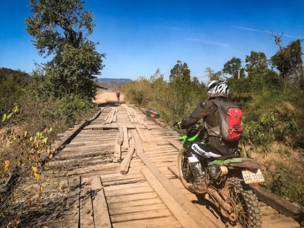
To really experience Vietnam's breathtaking nature and authenticity, the best way to tour the Ho Chi Minh Trail is with an Easy Rider, a local guide on a motorbike. Riding a motorcycle allows you independence that you won't get on a group trip or with public transportation (which is fairly basic in this region of the nation). During a tour, you will get the opportunity to walk portions of the actual Ho Chi Minh Trail.
In North Vietnam, you may quickly drive the Ho Chi Minh Trail from Phong Nha. Starting from Hoi An, Danang, Quy Nhon, or Dalat, you will go through the Central Highlands.
The Ho Chi Minh Trail invites you to travel back in time, following in the footsteps of one of history's most legendary routes. From the wild beauty of the North to the verdant landscapes of the Mekong Delta, the Ho Chi Minh Trail promises an adventure rich in historical and natural discoveries.
Maybe You Like This

.jpg)